LUCAS-MEGA Part 1: From Fragmented Soil Data to Usable Soil Intelligence

Kuangdai Leng
Research Scientist
I’m Kuangdai Leng, a Research Scientist at Earth Rover Program. My work focuses on AI methods for complex scientific systems, including multimodal representation learning, physics-informed modelling, and AI agents for data retrieval and data-grounded reasoning.

I joined ERP because soil is central to food, water, biodiversity, and land restoration, but its complexity and high variability also make it a challenging frontier for AI for Science.
This blog introduces our recent work: LUCAS-MEGA, an open, multimodal soil dataset built around the European LUCAS soil survey and enriched with 68 source datasets from the European Soil Data Centre. LUCAS-MEGA brings together more than 72,000 soil samples, nearly 30,000 georeferenced locations, and 1,017 variables covering soil chemistry, physics, hydrology, climate, land use, biological indicators, text, and images.
Alongside the dataset, we developed SoilFuser for scalable data fusion, SoilFormer for representation learning, and ERP-GPT-EU for data-grounded soil reasoning through natural language.
This is Part 1 of a two-part blog. Here, I focus on data construction and access: why LUCAS-MEGA was needed, how we built it, and how users can explore it through Hugging Face and a ChatGPT-based interface. In Part 2, which will be posted later, I will focus on SoilFormer and how models can learn from many soil and environmental variables at once.
Motivation: From Valuable Data to Usable Data
Europe already has a rich soil data ecosystem. The LUCAS soil survey provides direct measurements from field and laboratory sampling. Other European resources describe hydraulic properties, soil profiles, erosion risk, carbon stocks, land degradation, terrain, climate, land cover, trace elements, and many other dimensions of the soil environment.
The issue is not whether these resources are valuable. They clearly are. The issue is that they are difficult to use together.
For researchers and practitioners, the first barrier is usability. Relevant information may be spread across maps, spreadsheets, codebooks, metadata documents, and separate download portals. Before analysis begins, users often have to spend substantial time finding the right files, understanding what each variable means, and deciding whether different sources can be joined responsibly.
The second barrier is machine-learning readiness. Soil systems are not one-variable systems: carbon, texture, pH, nutrients, water, climate, land use, and biological processes interact continuously. But if soil data remains separated by source, format, and measurement convention, it is difficult to train models that learn soil as a connected system.
LUCAS-MEGA was built to address both barriers: making European soil data easier for people to access and inspect, while also creating a foundation for large-scale modelling.
Building LUCAS-MEGA
LUCAS-MEGA uses the European LUCAS soil survey as its primary backbone. LUCAS is a strong starting point because it provides observations tied to real locations, real samples, and consistent survey protocols. Around this backbone, we integrate additional European soil and environmental datasets into one shared structure: soil samples as rows, and soil or environmental variables as columns.
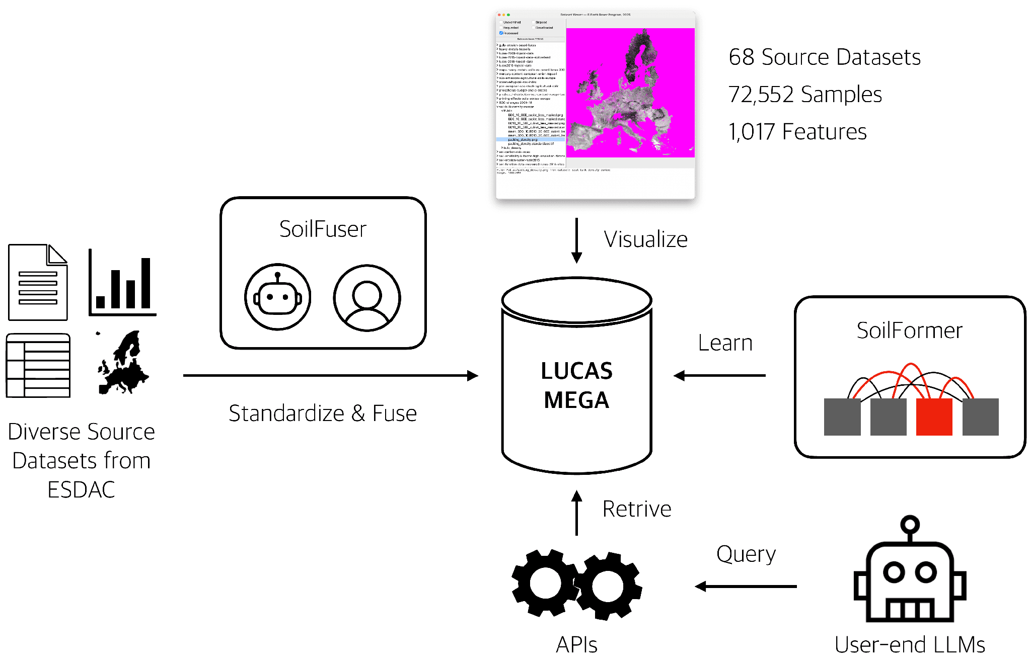
Overview of the LUCAS-MEGA pipeline from data fusion to modelling and application.
In practical terms, LUCAS-MEGA can be read like a very large table. Each row is a soil observation, and each column is a soil or environmental variable gathered from one or more sources.
The dataset includes numerical variables such as pH, organic carbon, bulk density, clay content, slope, elevation, rainfall, and nutrient indicators; categorical variables such as land cover class and soil group; and textual and visual information, including descriptions and site photographs where available.
SoilFuser: Standardising and Fusing Heterogeneous Sources
To construct LUCAS-MEGA, we developed SoilFuser, a multi-agent, human-in-the-loop pipeline for standardising and fusing soil data from many different formats and sources.
The starting point was 130 datasets hosted by the European Soil Data Centre. We reviewed them for relevance and usability, standardised the retained data, and fused the appropriate sources into one shared structure. In the end, 68 source datasets were integrated into LUCAS-MEGA.
AI agents helped generate processing scripts and mapping instructions, but the process was not left to automation alone. Human experts remained in the loop to validate results, resolve ambiguity, and prevent unreliable outputs. The role of agents was not to replace scientific judgement, but to make a large and repetitive integration task more scalable.
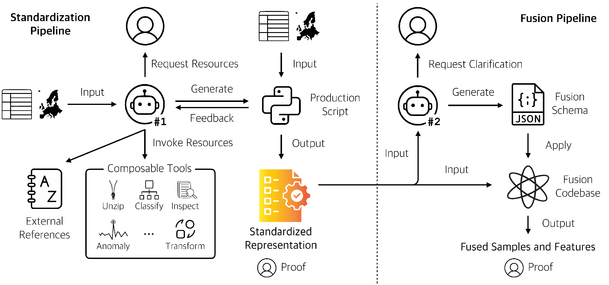
Overview of the SoilFuser system.
What “MEGA” Means
The name LUCAS-MEGA reflects four design goals.
Multimodal. The dataset combines numerical, categorical, textual, and visual information across soil chemistry, physics, hydrology, carbon, texture, trace elements, erosion, biodiversity, land use, climate, terrain, and more.
End-to-end machine-learning-ready. LUCAS-MEGA is released in formats that support direct analytical and modelling workflows, with standardised units, consistent variable names, and clear records of where values came from.
Great quality. The data fusion process includes checks for unit inconsistencies, invalid values, codebook mismatches, missing-value conventions, and other issues that commonly appear when many public datasets are combined.
Accessible. The dataset is released openly, with supporting resources that make it usable by researchers, developers, and environmental teams.
Access: From Dataset Download to Natural-Language Query
Open datasets are important, but a dataset download is not always the easiest entry point. Many users do not want to start by reading technical documentation, installing dependencies, or writing API calls. They want to ask a soil question and retrieve relevant evidence.
To make this easier, LUCAS-MEGA is paired with an access layer for data-grounded reasoning. The system connects natural-language questions to location handling, relevant variable selection, and data retrieval, so users can ask place-based or feature-based questions without manually navigating the full dataset.
Readers can try this directly through ERP-GPT-EU on ChatGPT. This is the easiest way to experience LUCAS-MEGA without downloading the dataset, installing software, or working through the API code.
For users who want direct access to the underlying assets, the dataset and supporting code are also available on Hugging Face.
Where Part 1 Leaves Us
Part 1 has focused on the data layer: how LUCAS-MEGA turns fragmented European soil and environmental resources into a more usable foundation for both people and models.
In Part 2, I will turn to the modelling side and explain how SoilFormer learns from many soil and environmental variables at once.
Open Resources
The LUCAS-MEGA resources are available openly: